

Bryce Canyon Scenic Drive: Best Overlooks, Hikes, and Things To Do in One Day

Bryce Canyon National Park, home of the geological hoodoos.
Whether you’re visiting Bryce Canyon as part of Utah’s Mighty 5 or you’re on a day trip to see Bryce’s red rocks landscape in person, when you visit Bryce Canyon National Park, you’re visiting the largest concentration of irregular rock formations called “hoodoos” that exist anywhere in the world.
It’s spectacular!
We visited Bryce with two of our best friends who were visiting us during our one-month stay in Kanab. While they were in town, we also wanted to explore the nearby Zion National Park, Grand Canyon North Rim, and Coral Pink Sand Dunes. So we had just one day set aside to soak up as much of Bryce Canyon’s magic as possible.
It was a big ask, and while there’s always going to be more to do and see in a national park, we left our day pleasantly surprised by how much we got to explore (and we know the expansive vistas from a dozen+ overlooks along Bryce’s scenic drive helped tremendously).
So, if you, too, only have one day to sightsee, here’s how to see Bryce Canyon National Park in one day and the best stops along Bryce Canyon Scenic Drive.

Table of Contents Hide
When to Visit Bryce Canyon National Park
Summer in Bryce can be busy and warm, but even warm summer months in Bryce are typically comfortable. (And the months of May and June typically offer the fewest days of rain, as opposed to the greater possibility of thunderstorms in the months of July and August.)
But for the most comfortable hiking temperatures alongside fewer crowds than summer allows, consider visiting in shoulder-season months like April, May, September, or October.
We visited Bryce Canyon National Park in late October, and the temperature was amazing. (Our group was split - some wearing long pants and some in shorts, while all of us were in short sleeves with a light jacket. We were very comfortable for a half day of driving and stopping at overlooks, plus a half day of hiking.)
Plus, by visiting towards the end of October, we got to see sections of Bryce Canyon under a light dusting of snow, which was absolutely stunning!
Of course, you can’t necessarily plan for snowfall in Bryce, but the snow season does typically begin in October, with most of the season’s snow falling between December and March.
So, while fall is probably the best time of year to visit for the best mix of smaller crowds, comfortable temperatures, and park openings, late fall or even winter would also be beautiful if you’re looking for an incredibly photogenic time to visit. (The contrast of white snow with red rocks is breathtaking!) Just know it can get quite cold in Bryce since it sits at high elevation, so bring layers!
Note: The National Park Service states that 60% of visitors come to Bryce between the months of June through September. To avoid crowds but still enjoy good weather, May, April, and October are your best bet. The fewest crowds will be found in winter, but if you visit then, plan to snowshoe and know many hikes and roads will be closed. (For example, at the time of writing in early March, the Bryce Canyon Scenic Drive is closed at mile 3 of 18, and the famous Wall Street side of the Navajo Loop is closed as well.)

Note: Bryce Canyon reaches an elevation of 9,100 feet. That’s part of why temperatures in the summer are typically manageable, and snow season can start in October. Because Bryce Canyon sits at such a high elevation, be prepared for the impact the altitude can have on your body. Take it easy if you’re planning to hike, and allow for plenty of breaks.
How to get to Bryce Canyon National Park
Bryce Canyon National Park is located in Southern Utah, about 1.5 hours from Zion National Park and Kanab, Utah.
To visit, you can road trip from a nearby state or fly into Las Vegas or Salt Lake City. Each airport is about 4 hours from Bryce Canyon Visitor Center, with the Las Vegas airport slightly closer than Salt Lake City.
For even closer but possibly more expensive or less convenient options, there are nearby regional airports you could consider as well. If you’d like to see the Grand Canyon or Sedona, AZ while in town, consider flying into Pheonix and road-tripping from there.
Since we were on a 3.5-month road trip through Colorado and Utah, we drove to Bryce Canyon from our short-term rental in Kanab. Our friends flew into Las Vegas and picked up a rental car to meet us there.
Where to Stay in Bryce Canyon
For access to Bryce Canyon National Park, you can stay in the park or a nearby city such as Tropic, Panguitch, or even Kanab.
We personally recommend staying in Kanab if you’re interested in visiting more than Bryce Canyon during your trip. Kanab is such a centrally located city in Southern Utah and is in proximity to many amazing things to do and see. Here are 9 more jaw-dropping sights you can visit from Kanab.
But if you’re only visiting for a short amount of time and want to explore as much of Bryce Canyon in one day as possible, stay as close to the park as you can. Consider The Lodge at Bryce Canyon (in the park), camping, or staying in the nearby towns of Tropic or Panguitch.
One-Day Bryce Canyon Itinerary
There are 3 things we recommend for your day in Bryce Canyon to get a good feel for what makes this park unique:
Drive the Bryce Canyon 38-Mile Scenic Drive (and stop at its 13 overlooks!)
Hike into the Bryce Canyon Amphitheater to walk among the Bryce Canyon hoodoos
Catch sunset over Bryce Canyon (and spend time marveling at the beauty of Bryce’s red rock landscape!)

Drive: Bryce Canyon’s 38-Mile Scenic Drive (& 13 Overlooks)
The first thing we love to do at any new national park is drive through as much of the park as possible to get our bearings.
Enter: Bryce Canyon’s 38-Mile Scenic Drive.
Of the national parks we’ve been to, Bryce Canyon has one of the best scenic drives when it comes to feeling like you’re able to see and experience a lot of the park from the drive alone. It’s one of the few where you can walk away with a good sense of the park seeing it solely from the road. (Compare this to a national park like Guadalupe, where you have to get into the backcountry to see it.)
So if you only have one day to see Bryce Canyon National Park, start here! Plan for at least 3 hours to drive this road and enjoy as many of the 13 overlooks as possible along the way. This is the absolute best way to see Bryce Canyon National Park in one day.
Contrary to its neighbor, Zion, you can drive your own vehicle into Bryce Canyon. This is our recommendation, as driving your own vehicle will give you more flexibility in how you spend your day and where you stop, plus for how long.
However, if you prefer not to drive through Bryce Canyon yourself, you can tour parts of the park using the Bryce Canyon Shuttle Bus. From April through mid-October, the shuttle bus can provide you with transportation to some of the park’s most popular overlooks and trails.
This could be a great option if you’d like to avoid parking challenges during busy months. Although you won’t see the entirety of Bryce’s scenic drive, the shuttle does take you to the park’s four most popular overlooks, including Bryce Point, Inspiration Point, Sunrise Point, and Sunset Point. Learn more about the Bryce shuttle here.
RTL Tip: Consider driving your own vehicle along the Bryce Canyon Scenic Drive. Then, hop on the shuttle bus at the visitor center to see Bryce Point, Inspiration Point, and Sunrise/Sunset Point. If you’re going to hike any combination of Navajo Loop, Queens Garden, or Peekaboo Loop, the shuttle will take you where you need to be to begin your hike without worrying about parking!
Rainbow Point
Rainbow Point is the furthest overlook on the Bryce Canyon Scenic Drive and sits at the highest elevation in the park. We recommend driving all the way to Rainbow Point first, then stopping at the overlooks on your way back.

Rainbow Point Overlook, Bryce Canyon
Ponderosa Point (Ponderosa Canyon)
Stop at as many of the 13 viewpoints as you can because all views are slightly different, each highlighting a different feature of Bryce Canyon. Some viewpoints better highlight the hoodoos, others highlight the contrast between the red rocks and green pine trees, and some showcase the beauty of the Bryce Canyon ridge.

Ponderosa Canyon, Bryce Canyon National Park
Natural Bridge
The Natural Bridge Overlook was my favorite overlook for viewing the intensity of Bryce Canyon’s red rocks, especially if you’re able to catch the light around mid-morning/early afternoon. The orangish-red vibrancy of the rocks is stunning!

Natural Bridge Overlook, Bryce Canyon
Swamp Canyon
Swamp Canyon gets its name because, compared to the rest of Bryce Canyon National Park, this area is “a virtual wetland”. Check out each viewpoint to experience the varied landscape and geology of Bryce, then come back to let us know your favorite in the comments below!

Swamp Canyon Overlook
Hike: Navajo Loop to Queens Garden Trail
One of the most popular hikes in Bryce Canyon National Park is the 2.9-mile Navajo Loop to Queen’s Garden Trail. You can start this trail from either Sunset or Sunrise Point and choose to walk either clockwise or counter-clockwise.
We choose to park and begin our hike at Sunset Point, walking counter-clockwise. This meant we were walking ‘Wall Street’ first. Wall Street is one of the most picturesque views in Bryce Canyon National Park. (More on that below!)
The Navajo Loop to Queens Garden hike includes two trails that combine for one of the best hikes in Bryce Canyon. You’ll get to walk through open, vast views of hoodoos on the Queens Garden Trail and also pass through narrow sections of tall red rock along the Navajo Loop. Add in the short walk between Sunrise and Sunset Point, and you get to see some of the most magnificent views in the entire park.
The National Park Service recommends hiking this trail clockwise, which means starting at Sunset or Sunrise Point and walking down the Queens Garden Trail first. The NPS recommends this for two reasons: (1) The Queens Garden side is less steep (which means you’ll be walking down the less steep section and up the steeper section, which is typically advised for limiting the risk of injury), and (2) The views along this part of the trail are absolutely incredible, so walking down this side will give you the opportunity to enjoy them in front of you (vs. having to turn around or view them over your shoulder).
That said, we were recommended to walk counter-clockwise and were very happy to be looking toward the switchbacks of Wall Street during our descent (it’s an iconic view). Reading reviews from others, many seemed happy to save the less strenuous portion of the hike (walking up the less steep Queens Garden vs. the steeper Wall Street) for the end of the hike.
RTL Tip: If I had to redo this hike with what I know now, I’d walk clockwise from Sunset to Sunrise Point, down Queens Garden, and up the Navajo Loop Two Bridges trail. Once I returned to Sunset Point, I’d walk counter-clockwise down the Navajo Loop Trail through Wall Street, then follow the trail back to Sunset Point or add on the hike to Peekaboo Loop.
If you only have time for one hike, we recommend the Navajo Loop to Queens Garden counter-clockwise. If you’re looking for a shorter hike, walk the Navajo Loop from Sunset Point at least down to Wall Street, then walk from Sunset Point to Sunrise Point along the Rim Trail.
Hike Summary
Navajo Loop: 1.4-mile hike, Start and End at Sunset Point, Hike Counter-Clockwise down Wall Street
Navajo Loop to Queens Garden Trail: 2.9-mile hike, Start at Sunset Point, Hike Clockwise to Sunrise Point and down Queens Garden (for a less steep descent and better vista views) or Hike Counter-Clockwise from Sunset down Wall Street (for a less strenuous ascent and better Wall Street views)
Queens Garden to Navajo Loop + Navajo Loop to Peekaboo Loop (becomes sort of a figure 8 hike): 9+ miles, Start at Sunset Point, Walk to Sunrise Point, Hike Queens Garden Trail to Navajo Loop (walking clockwise up the Two Bridges side), Back at Sunset Point, Start the Navajo Loop (walking counter-clocking down Wall Street), Continue on the Peekaboo Loop Trail (Full Loop), Then walk back to Sunset via the Navajo Loop Trail (your choice which side!)
Note: For all hikes, you can start and end at either Sunset or Sunrise Point. While that means you can start at one and end at the other (if you’re using shuttle transportation and don’t need to return to your car), we recommend starting and ending at the same location. This way, you’ll get to walk the Rim Trail between Sunset and Sunrise. It’s incredible!
Below, we’ll share some of the best things to see following the Navajo Loop counter-clockwise from Sunset Point!

In the image above, we’ve placed stars next to some of the most popular things to see in Bryce Canyon: Sunset Point (where you’ll start the Navajo Loop), Wall Street (along the Navajo Loop), Two Bridges (if you choose to return to Sunset Point via the Navajo Loop), and Queens Garden (where you’ll cross through the doorway mentioned below to continue toward Sunrise Point- more on this below).

This is the trail you’ll follow to hike Navajo Loop Trail to Queens Garden Trail (passing through Wall Street).
Thor’s Hammer
Thor’s Hammer is one of the most well-known hoodoos in Bryce Canyon (and one of the most iconic photographs to snap if you’re a photographer).
Sunset Point and the Navajo Loop offer great views of Thor’s Hammer. It sits just below the overlook for Sunset Point, and if you begin the Navajo Loop trail, you’ll come upon even better viewpoints.
It’s worth walking this trail for views of Thor’s Hammer and Wall Street alone. These are two of the most iconic sights to see in Bryce Canyon National Park. While we recommend walking the entire trail so you can spend extra time among the hoodoos, you can walk about .45 miles to Wall Street (then turn around) for views of both Thor’s Hammer and Wall Street.
You could also choose to walk only the Navajo Loop Trail, which is about 1.4 miles long and passes by Thor’s Hammer, Wall Street, and the Two Bridges.

Thor’s Hammer, Near Sunset Point, Bryce Canyon
Wall Street
As you start the Navajo Loop Trail from Sunset Point, you’ll follow a set of switchbacks into the red, narrow walls of a section of Bryce Canyon known as Wall Street.
This is another popular viewpoint of Bryce Canyon (and another iconic place to take a photo - don’t miss this!).
Wall Street is gorgeous and was my favorite area (and favorite photo taken) from our day in Bryce Canyon National Park. This area of Bryce Canyon is so aesthetically pleasing as you walk along switchbacks in a narrow section of tall red rock formations. Walking among the rock formations and hoodoos while they tower beside you is spectacular.
Note: Don’t want to hike much, but do want to see Wall Street? Park at Sunset Point and walk the beginning of the Navajo Loop Trail counter-clockwise. You’ll travel steep switchbacks into Wall Street, and then you can turn around to return to Sunset Point without walking the rest of the loop.

Walking the Navajo Loop from Sunset Point to Wall Street

Wall Street, Bryce Canyon National Park
Queens Garden
While Wall Street was by far my favorite view along this trail, I also really enjoyed the vastness of the Queens Garden.
After walking through Wall Street, you can follow the Navajo Loop back to Sunset Point, or you can follow the signs to continue toward Queens Garden. If you do this, you’re ultimately walking in the direction of Sunrise Point.
This trail is pretty well defined, except for one confusing section near the Queens Garden (it tripped up our group and two other groups of hikers we were near!). Essentially, you’ll see what appears to be a doorway you could walk through but also a trail you could continue taking straight.
By walking straight (when the door is on your right), you’ll explore a little bit more of the Queens Garden. Do this. You’ll be standing in the middle of large and imposing hoodoos. It’s remarkable. However, there is no trail exit from here. You will need to come back to walk through this doorway (pictured below) and continue following the trail on the other side to Sunrise Point.
We recommend exploring the Queens Garden, then continuing toward Sunrise. While Wall Street was my favorite section from a photography point of view, Queens Garden (and the views just before Sunrise Point) were the most incredible from a landscape perspective. It’s grand, vast, and magnificent! And, in my opinion, here’s where you’ll find the most expansive views of the hoodoos from anywhere along the trail.

Ignore the awkward hand caught mid-pose and focus on the grandeur of standing in the midst of imposing hoodoos!
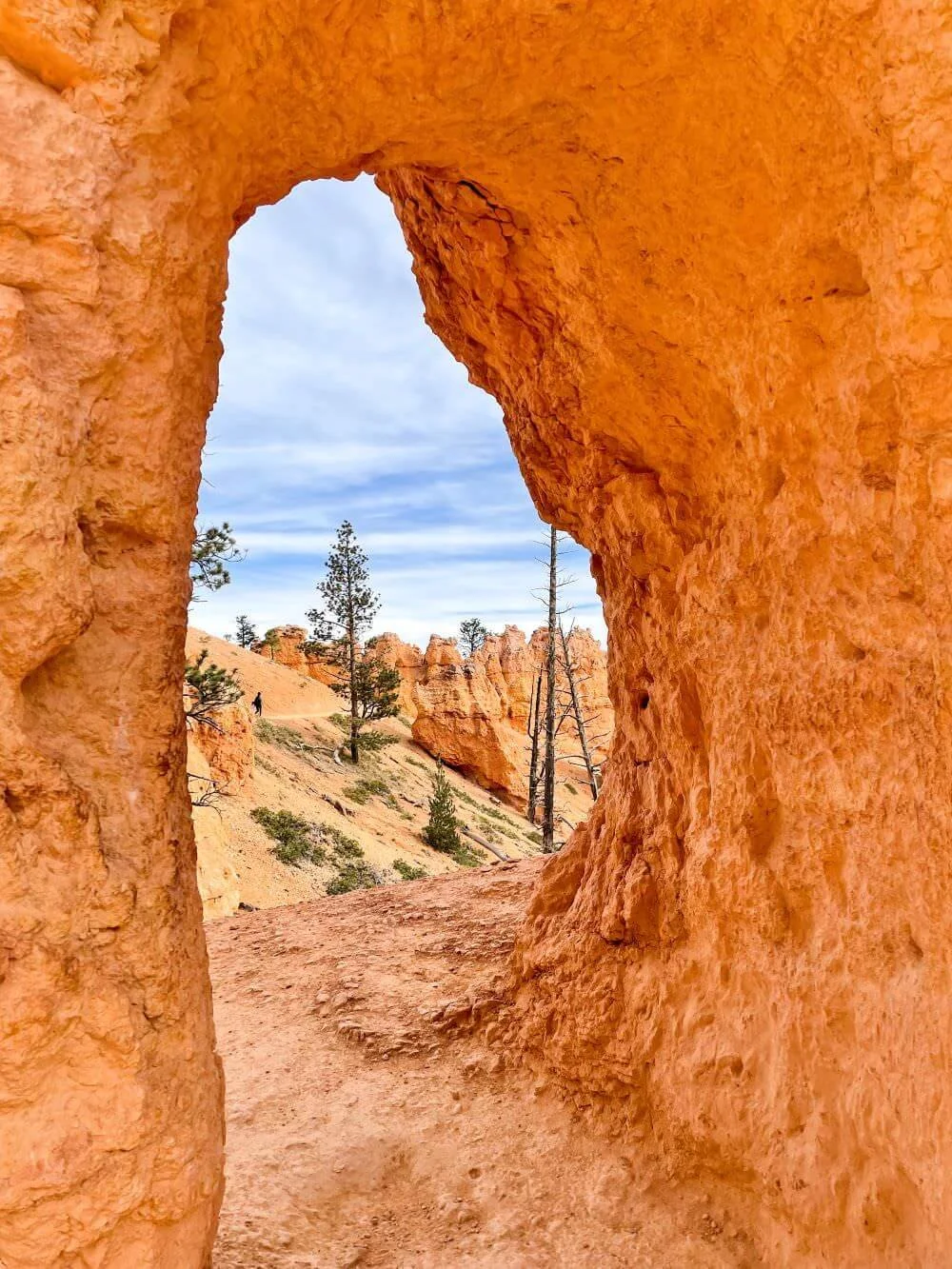
The trail continues through this ‘doorway’. (When this is on your right, you can continue straight to Queens Garden, but ultimately you’ll pass through this to get to Sunrise Point.)

Walking on the other side of that doorway toward Sunrise Point.
Rim Trail between Sunrise and Sunset Point
Although we recommend you start the Navajo Loop to Queen Gardens at Sunset Point, continue following the loop all the way back around to Sunset Point so you can start and end at this gorgeous spot.
This way, you ensure you walk the Rim Trail between Sunrise and Sunset Point, which has some of the most magnificent views of the Bryce Canyon Amphitheatre.

Enjoy the view: Sunset (or sunrise) over Bryce Canyon Amphitheatre
The Bryce Canyon Amphitheatre is where you’ll find more concentrated hoodoos than anywhere else in the world. After walking through this during your hike, drive to your favorite overlook to relax and enjoy the view.
Although you won’t get the sun setting over Bryce Canyon (as its overlooks and viewpoints face east), park rangers recommend Inspiration Point or Paria View for the best sunset colors. (Aim to be there for golden hour - the hour before sunset - for the best lighting.)
For sunrise, consider Sunrise Point or Bryce Point.
What the National Park Service recommends if you only have one day: Make sure to see Bryce Point, Inspiration Point, Sunset Point, and Sunrise Point. These are the most popular views in the park. Begin at Bryce Point, which is the southernmost view of Bryce Canyon and perhaps the best view into the Bryce Amphitheater.
Is Bryce Canyon dog-friendly?
Dogs are allowed on most paved viewpoints along the Bryce Canyon Scenic Drive (excluding Piracy Point). Dogs are also allowed at campgrounds, parking lots, and on the paved section of the Rim Trail between Sunset and Sunrise Point.
Dogs are not allowed on the Navajo Loop and Queens Garden Trail. For dog-friendly hiking, the National Park Service recommends the Dixie National Forest and the Red Canyon Visitor Center.
Note: Dogs are allowed on the ‘Shared Use Path’ between the entrance and Inspiration Point.
More Places to See Near Bryce Canyon
There’s so much to do in Southern Utah and plenty of amazing activities near Bryce Canyon! If you can extend your trip, consider planning a visit to one or more of these jaw-dropping places to see.
About 1.5 hours from Bryce Canyon, you’ll find Zion National Park and two of the most famous national park hikes in the states: Angel’s Landing and The Narrows.
Want to visit all 5 national parks in Utah? Click here for a Mighty 5 Road Trip Itinerary (which includes Zion National Park, Bryce Canyon, Canyonlands, Capitol Reef, and Arches National Park).
Coral Pink Sand Dunes is also about 1.5 hours from Bryce Canyon (in the direction of Kanab, Utah). If you’re looking for somewhere to stay to take advantage of everything Southern Utah has to offer, we highly recommend Kanab. From there, you’ll also have access to Antelope Canyon, The Wave, and even the Grand Canyon North Rim.
Here are 10 jaw-dropping things to do and see near Kanab!

Zion National Park, Photo taken during the Angel’s Landing Hike
Please leave us a comment below!
What’s your favorite thing to do in Bryce Canyon National Park, or which of these views would you most like to see? We’d love to hear from you in the comments below!
Save this itinerary for a future road trip
Hover over the image below and click on the red “Save” button that pops up in the upper lefthand corner of the image to save this on Pinterest for later. (If you’re on mobile, you might have to tap the image first to see the red ‘Save’ button.)

