

(#3) Driving The Icefields Parkway
Turquoise lakes? Check. Epic mountain views? Check. A moment of 5-star luxury as we travel through the Canadian Rockies from Calgary to Jasper National Park? Double check! 😍
For this diary-style travelogue, we’re bringing you along as we take the dreamiest 10-day road trip through the Canadian Rockies, stopping in places like Banff, Lake Louise, and Jasper National Park and driving the Icefields Parkway — twice!
Later on, we'll share detailed itinerary posts to help you plan your own Canadian Rockies Road Trip, but in the meantime, this diary-style travelogue is dedicated to sharing the fun adventures — and a few misadventures — of our own. Wondering if this bucket-list destination really lives up to the hype? Let’s go!

The Icefields Parkway
Day 4: Bow Summit, Cephren Lake, Mistaya Canyon
I drop to my knees, my face in my hands, full-on sobbing at the summit of a mountain in the Canadian Rockies.
How’d we get here?
Day 4 of our 10-day Canadian Rockies Road Trip begins with excitement for the drive ahead. We're kickstarting our three-day adventure along the Icefields Parkway, driving from Lake Louise to Jasper National Park, a route often celebrated as one of the world's most awe-inspiring drives!
The Icefields Parkway has been honored as one of National Geographic's "Drives of a Lifetime" and consistently makes lists of top scenic routes by travel publications like Lonely Planet and Travel + Leisure. Connecting a myriad of glaciers, cascading waterfalls, pristine mountain lakes, and rugged peaks, the Icefields Parkway is constantly in conversation as one of the world’s ultimate road trips.

One of my favorite shots along The Icefields Parkway 😍
For this leg of our trip, as we head toward Jasper National Park, we’ll spend three days and two nights hiking, driving, and exploring the Icefields Parkway. At the end of our 10-day Road Trip, we’ll retrace our steps as we drive from Jasper to Waterton Lakes National Park headed for the States.
We spent last night at Silverhorn Creek Campground, a dry campground on the Parkway that’s close to the popular Peyto Lake viewpoint.
We’re feeling pretty good this morning, guestimating about a 50% increase in sleep comfort thanks to the new camping pads we picked up in Lake Louise. (The ones we bought to make our transition back to car camping just a little bit easier after our magical stay at the Fairmont Chateau Lake Louise!)
It was cloudy and drizzling as we went to sleep last night, and the weather hasn’t cleared this morning. It’s no longer raining, but visibility is even worse waking up. We can’t see the mountains on either side of the valley we’re in, and as we hit the road for our first stop of the day, the fog is so thick we can barely see the road ahead of us.

You’d have no idea we’re driving one of the most spectacular roads in the world…
We’re on our way back to Peyto Lake, hoping the fog will clear enough for us to get a sunrise view of one of the most beautiful lakes along the Icefields Parkway.
Unfortunately… it doesn’t, and Peyto Lake is completely and entirely clouded by fog. If we weren’t just here yesterday, we’d have no idea there was a bright turquoise lake in the distance ahead.
Thinking the fog may dissipate as temperatures rise, we decide to spend an hour or so hiking from Peyto Lake to Bow Summit.
The Bow Summit Trail starts at the Peyto Lake viewpoint, follows a short paved path through the woods, then opens up into a large dirt trail.
This large dirt trail leads to MANY smaller offshoots, making us feel more than usual like hiking is just an invitation to get lost in the woods. There are side trails and forks in the path at almost every turn.
At one point, we encounter three different paths to choose from. I begin pointing to a path that clearly leads to a trail of switchbacks up the mountain in front of us (we’re headed toward the summit, right?) when Jonathan exclaims, “This way!”
I turn to see him pointing at a handmade arrow of rocks on the ground, telling us to follow the path straight in front of us.
“Okay then…
Here’s hoping this is an official arrow of rocks and not the beginning of a horror movie?”

Would you follow the arrow or take one of the paths to its left? 🤔
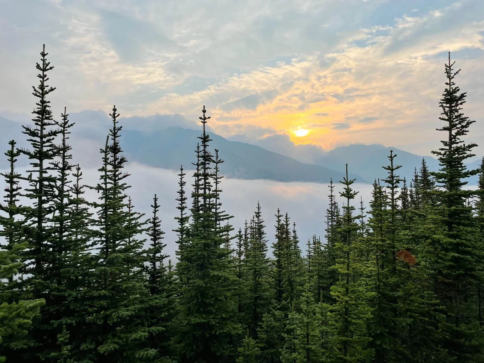
We follow the arrow and ascend toward the summit, quickly finding ourselves climbing above the clouds and fog. It’s incredible!
The pine trees that line our path are wet from rain the night before, making their forest-green needles even more vibrant. The fog’s now a thick blanket covering the valley to our left, with silhouettes of distant mountain peaks just visible below the sun that’s now peeking out between the clouds.
It all feels like a very wild, raw landscape.
Add to that the fact that we haven’t seen one other person since we left the Peyto Lake viewpoint about an hour ago, and a surprisingly comfortable sense of solitude settles over us, heightening the rawness of our view.
The view to the left of the path

Lincoln loving the solitude!

Warming up as we climb, but loving the sunrise we couldn’t see below the fog.
Eventually, we reach the summit, or at least as far along the path as we’re wanting to hike this morning, and we start taking selfies against the backdrop of the sunrise.
I look at the pictures to see how they turn out, but something immediately looks off. It takes me a moment to realize what.

My hands are bare.
There’s no ring on my left hand.
Normally, this wouldn’t be a huge deal, as I almost exclusively wear silicone bands during travel seasons since we move around a lot and spend much of our time outside.
However, we just spent the night at Lake Louise and I wanted to feel fancy for the evening, so I put on my actual engagement ring and wedding band. I forgot to pack them away when we arrived at the campground last night… which means they should be on my hand right now.
All of this is running through my mind in a split second, and I think back to last night.
We were getting ready for sleep after setting up our car camping bed in the backseat. I put some lotion on my hands at the tail end of the night… taking off my rings and putting them in my… POCKET! The pocket of the jacket I’m wearing right now.
Immediately, I feel for the rings in my jacket pocket, but it’s empty. Panic’s rising, but then I feel a small band in the corner. It’s my wedding band. But even as I flip the pocket inside out to ensure I don’t miss anything, my engagement ring isn’t there.
I’ve lost my diamond ring in the middle of the Canadian Rockies, and there I go, dropping to my knees and putting my face in my hands, full-on freaking out at the summit of this mountain.
Tears well up as I frantically search through every pocket in my jacket, pants, and hiking bag. I’m spiraling with possibilities: Did the ring fall out during the hike? While I was sleeping? At the campground? Did I accidentally throw it out with the trash this morning?
These are the four main ideas I have for where my ring could be. Either it’s… (1) somewhere along this trail we just walked, falling out when I took off my jacket about halfway up the hike (or possibly at any other point along the way?), (2) in the car because it fell out of my pocket during the night and onto the floor or in our sheets somewhere, (3) on the ground at our campsite, falling out when getting in or out of the car or when packing up this morning, or (4) in the trash we threw away when leaving the campground this morning.
You know that pit in the bottom of your stomach when you realize a mistake you may not be able to correct?
It’s not an understatement to say I’m feeling a bowling ball-sized pit right now, but I also know I can’t completely lose it on the summit of this mountain.
My best bet is my ring’s in the car or trashcan at the campground, but since I don’t know for sure, we immediately grab our things and start the trail back, looking down at our feet for anything shiny along the way.
We’re looking for a probably one-inch by one-inch ring on a four-mile hike. “It’s like looking for a needle in a haystack,” Jon says as we’re closely watching the ground retracting our steps.
I’m upset with myself, of course, but trying to stay light-hearted since I need my wits to search for the ring. I turn to Jonathan, half joking and half serious, and say, “This cannot be happening. I cannot go home and explain to our families that I lost my ring before you!”
You see, everyone gives Jon a hard time for regularly throwing his ring in the air, rolling it across the table, and making up games to play with it (you know, only-child style).
And everyone comments on this, from his mom to his best friend to my siblings and so forth. It’s become a running joke at family get-togethers and holiday parties to ask Jonathan — when his ring is mid-air after his latest toss — how many times he’s lost his ring already.
His answer? Never. Not once. Not even a moment of thinking he’s lost his ring. (Though to be fair, his ring has come within inches of an air vent or drain a time or two…)
This is what I’m thinking about as we retrace our steps down the mountain. I absolutely… cannot… under ANY circumstances… go home to become the new running joke of the family, having to answer until the end of time for losing my ring before Jon. 🥴😩
So… Please, God, provide some divine intervention 🙏🙏😅
Every dewdrop and shiny object tricks us into thinking we’ve found it, but we’re empty-handed by the time we reach the base of the mountain.
We skip the Peyto Lake viewpoint — which is an easy decision since the fog’s just as thick and not even a speck of the blue lake we saw here yesterday is visible — and I’m thinking about all of the places my ring could still be.
The car?
The campground trashcan?
Somewhere along the hike we just left?
We get back to the car and come up empty-handed once more as we search the floorboards, under the mats, and around the backseat. I’m feeling less and less confident each place we search, and the reality of the situation is getting real as we drive away from Peyto Lake to check the campground next.
If it fell during the hike, my ring’s gone.
The pit in my stomach grows as we get back to the campground and head straight to the trashcans. I start with the area around the trashcan, just in case it fell when we were grabbing trash from the car and depositing it into the dumpster earlier this morning.
There’s so much moving around on these road trips — so much taking things in and out of the car, throwing things away — that it’s a challenge to keep everything in its place.
I even open the dumpster door, realizing it’s large enough that should I need to go dumpster diving, I can step into it. I don’t want to, for sure, but I could fit inside, and surprisingly, that’s a relief!
But before my last resort of stepping inside the dumpster, we check our campsite, then go through the car.
Jon’s pulling up the compartment holding the spare tire, and we’re checking every inch of the car and our items inside. Floor mats. Backpacks. Lincoln’s gear. Everything.
My last hope lies in the bag of bedding. It’s the last thing to check before it’s time to put on my big girl pants and go dumpster diving.
So I take a deep breath and slowly unzipper the bag. On top is the green fitted sheet we use over the back seats of the car when folded down. I grab the sheet out of the bag and…
Plop!
There, on the gravel ground, has fallen my beautiful, engraved engagement ring 😭😭😭
“JON!!!!”
A mix of relief and disbelief washes over me… followed by a few prayers of gratitude… then a small request for drama on future trips to come in the form of surprise upgrades and serendipitous moments rather than lost items like diamond rings and memory cards from once-in-a-lifetime excursions. 😅

I was too panicked, then relieved, to think about taking photos, so here’s one of our campsite the night before. This is ultimately where I lost my ring and found it!
Ready to shake off our unexpectedly eventful morning, it’s time to repack the car and officially check out of the campground, headed toward our next stop along the Icefields Parkway.
We’re on our way to Cephren Lake, a pristine alpine lake at the end of an out-and-back 7.5-mile trail near Waterfowl Lakes Campground.
The trail itself isn’t the reason to pick this hike — it’s a relatively flat but super rooty walk through the woods — but rather what’s at the end of the trail that’s worth the effort. There lies a serene alpine lake surrounded by glaciers and towering peaks, including Mount Cephren.
The temperature is cool this morning, so we’re getting big fall vibes as we walk through a forest of trees almost the entire way. Last night’s rain makes every step a mud pit, so we do our best to navigate the roots along the path in front of us.

The trail — about 3.5 miles of crossing roots and mud
On a sunny, dry day, this would be a gorgeous hike through the woods that leads to your own private lake oasis with mountain and glacier views. But today, when it's been raining for the last 24 hours, you're just trying not to slip on one of the thousands of tree routes you have to traverse along the path.
Jon’s not a big fan of this hike (perhaps tired after all the excitement this morning!?), but Lincoln has no problem prancing through the mud, happy to trot right through!

This photo is actually from New Mexico in 2020, but just a glimpse into how much Lincoln doesn’t mind a muddy hike 😅
After about an hour, the path spits us out to the shore of Cehpren Lake, and it’s like stumbling upon a secret hideaway in the Rockies. I mean, sure, we followed a path to get here intentionally, but when the trees thin just enough to show off the bright teal lake a hundred yards ahead, you kind of can’t believe your eyes.
How is this here? How does this much beauty exist along such a relatively small stretch of road?
You can’t help but think about the numerous pull-offs and quick viewpoints along the Icefields Parkway. They are ALL incredible. Any one of them will cause your jaw to drop.
There is pull-off after pull-off worthy of stopping your car to take a picture. Then, there are even more spots for you to park and walk just a handful of steps to get a view unlike anything you’ve seen before. Bluer lakes than you’ve ever seen. New shades of lakes you didn’t realize existed.
And still, somehow, there are just as many, if not once again more, opportunities to get onto a trail or into the backcountry for yet another stunning view… but these quieter destinations off the beaten path feel like stumbling upon a secret oasis just for you.
It takes your breath away.
This abundance of beauty is what makes the Icefields Parkway - and the Canadian Rockies in general - so magical.
It’s at this point that I’m starting to conceptualize the magnitude of this drive and why it’s consistently ranked as one of the greatest road trips in the world. There is truly so much to see along just 232 km.
We walk our final few steps to the shore, then follow the edge of the lake to a large rock where we can sit. Our backs are to the forest we just traveled through, and although there’s more mud and root navigating ahead, for now, we enjoy the rest and take lots of photos to add another happy bookmark to our Rockies adventure!

Sooooo happy when we finally spotted teal through the trees!!

Lincoln hanging out on the shore of Cephren Lake
Today’s third and final stop along the Icefields Parkway is Mistaya Canyon.
So after we travel back through the mud to our car, we drive about 6 minutes down the road to Mistaya Canyon. Mistaya Canyon is a narrow gorge carved by the Mistaya River over centuries. The deep, rocky walls of the canyon frame rushing turquoise waters, and it’s mesmerizing to watch!
One of the most fun features of this stop along the Icefields Parkway is the opportunity for easy exploration. You can walk along the canyon's edge, crossing over natural bridges and noticing the power of the river as it rushes through the narrow passageways.
Despite the adventure of Bow Summit and the beauty of Cephren Lake, this is probably my favorite stop of the day. After a quick downhill walk, there are plenty of areas to explore and even more places to take a seat and enjoy an up close and personal view of the canyon.
We can’t check in to our hotel, The Crossing Resort, for another hour or so, so that’s what we do. We sit on the rocks next to the canyon, every once in a while catching what looks like a shooting rainbow as the sun interacts with the water’s mist.


It’s been a long, incredible first day exploring the Icefields Parkway, but now, we’re ready for a similarly long hot shower and a warm bed.
We’re staying at The Crossing Resort, which sits at about the halfway mark of the Icefields Parkway. Our first impression is that this place resembles a tourist trip, but hey, our room has super hot running water, an indoor bathroom, and a place to eat — and that’s a huge win!
Tomorrow, we continue exploring the Icefields Parkway as we head toward Parker Ridge, the Columbia Icefield, Athabasca Glacier, and Sunwapta Falls!
